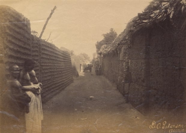
With its mathematical layout and earthworks longer than the Great Wall
of China, Benin City was one of the best planned cities in the world
when London was a place of ‘thievery and murder’. So why is nothing
left?
 |
| Benin City was described as ‘wealthy and industrious, well-governed and richly decorated’.
Illustration: Decompiling Dapper: A Preliminary Search for Evidence
|
This is the story of a lost medieval city you’ve probably never heard
about. Benin City, originally known as Edo, was once the capital of a
pre-colonial African empire located in what is now southern
Nigeria. The Benin empire was one of the oldest and most highly developed states in west Africa, dating back to the 11th century.
The
Guinness Book of Records
(1974 edition) described the walls of Benin City and its surrounding
kingdom as the world’s largest earthworks carried out prior to the
mechanical era. According to estimates by the New Scientist’s Fred Pearce,
Benin City’s walls were at one point “four times longer than the Great
Wall of China, and consumed a hundred times more material than the Great
Pyramid of Cheops”.
Situated on a plain,
Benin
City was enclosed by massive walls in the south and deep ditches in the
north. Beyond the city walls, numerous further walls were erected that
separated the surroundings of the capital into around 500 distinct
villages.
Pearce writes that these walls “extended for some 16,000 km in all,
in a mosaic of more than 500 interconnected settlement boundaries. They
covered 6,500 sq km and were all dug by the Edo people … They took an
estimated 150 million hours of digging to construct, and are perhaps the
largest single archaeological phenomenon on the planet”.
Barely any trace of these walls exist today.
Benin City was also one of the first cities to have a semblance of
street lighting. Huge metal lamps, many feet high, were built and placed
around the city, especially near the king’s palace. Fuelled by palm
oil, their burning wicks were lit at night to provide illumination for
traffic to and from the palace.
When the Portuguese first “discovered” the city in 1485, they were
stunned to find this vast kingdom made of hundreds of interlocked cities
and villages in the middle of the African jungle. They called it the
“Great City of Benin”, at a time when there were hardly any other places
in
Africa
the Europeans acknowledged as a city. Indeed, they classified Benin
City as one of the most beautiful and best planned cities in the world.
In 1691, the Portuguese ship captain
Lourenco Pinto observed:
“Great Benin, where the king resides, is larger than Lisbon; all the
streets run straight and as far as the eye can see. The houses are
large, especially that of the king, which is richly decorated and has
fine columns. The city is wealthy and industrious. It is so well
governed that theft is unknown and the people live in such security that
they have no doors to their houses.”
In contrast, London at the same time is
described by Bruce Holsinger,
professor of English at the University of Virginia, as being a city of
“thievery, prostitution, murder, bribery and a thriving black market
made the medieval city ripe for exploitation by those with a skill for
the quick blade or picking a pocket”.
African fractals
Benin City’s planning and design was done according to careful rules of symmetry, proportionality and repetition now known as
fractal design. The mathematician Ron Eglash, author of African Fractals
– which examines the patterns underpinning architecture, art and design
in many parts of Africa – notes that the city and its surrounding
villages were purposely laid out to form perfect fractals, with similar
shapes repeated in the rooms of each house, and the house itself, and
the clusters of houses in the village in mathematically predictable
patterns.
As he puts it: “When Europeans first came to Africa, they considered
the architecture very disorganised and thus primitive. It never occurred
to them that the Africans might have been using a form of mathematics
that they hadn’t even discovered yet.”At the centre of the city stood the king’s court, from which extended
30 very straight, broad streets, each about 120-ft wide. These main
streets, which ran at right angles to each other, had underground
drainage made of a sunken impluvium with an outlet to carry away storm
water. Many narrower side and intersecting streets extended off them. In
the middle of the streets were turf on which animals fed.
 “Houses are built alongside the streets in good order, the one close to the other,” writes the 17th-century Dutch visitor Olfert Dapper.
“Adorned with gables and steps … they are usually broad with long
galleries inside, especially so in the case of the houses of the
nobility, and divided into many rooms which are separated by walls made
of red clay, very well erected.”
Dapper adds that wealthy residents kept these walls “as shiny and
smooth by washing and rubbing as any wall in Holland can be made with
chalk, and they are like mirrors. The upper storeys are made of the same
sort of clay. Moreover, every house is provided with a well for the
supply of fresh water”.
Family houses were divided into three sections: the central part was
the husband’s quarters, looking towards the road; to the left the wives’
quarters (
oderie), and to the right the young men’s quarters (
yekogbe).
Daily street life in Benin City might have consisted of large crowds
going though even larger streets, with people colourfully dressed – some
in white, others in yellow, blue or green – and the city captains
acting as judges to resolve lawsuits, moderating debates in the numerous
galleries, and arbitrating petty conflicts in the markets.
The early foreign explorers’ descriptions of Benin City portrayed it
as a place free of crime and hunger, with large streets and houses kept
clean; a city filled with courteous, honest people, and run by a
centralised and highly sophisticated bureaucracy.
The city was split into 11 divisions, each a smaller replication of
the king’s court, comprising a sprawling series of compounds containing
accommodation, workshops and public buildings – interconnected by
innumerable doors and passageways, all richly decorated with the art
that made Benin famous. The city was literally covered in it.
The exterior walls of the courts and compounds were decorated with horizontal ridge designs (
agben)
and clay carvings portraying animals, warriors and other symbols of
power – the carvings would create contrasting patterns in the strong
sunlight. Natural objects (pebbles or pieces of mica) were also pressed
into the wet clay, while in the palaces, pillars were covered with
bronze plaques illustrating the victories and deeds of former kings and
nobles.
At the height of its greatness in the 12th century – well before the
start of the European Renaissance – the kings and nobles of Benin City
patronised craftsmen and lavished them with gifts and wealth, in return
for their depiction of the kings’ and dignitaries’ great exploits in
intricate bronze sculptures.
“These works from Benin are equal to the very finest examples of European casting technique,” wrote
Professor Felix von Luschan,
formerly of the Berlin Ethnological Museum. “Benvenuto Celini could not
have cast them better, nor could anyone else before or after him.
Technically, these bronzes represent the very highest possible
achievement.”
What impressed the first visiting Europeans most was the wealth,
artistic beauty and magnificence of the city. Immediately European
nations saw the opportunity to develop trade with the wealthy kingdom,
importing ivory, palm oil and pepper – and exporting guns. At the
beginning of the 16th century, word quickly spread around Europe about
the beautiful African city, and new visitors flocked in from all parts
of Europe, with ever glowing testimonies, recorded in numerous voyage
notes and illustrations.
Lost world
Now,
however, the great Benin City is lost to history. Its decline began in
the 15th century, sparked by internal conflicts linked to the increasing
European intrusion and slavery trade at the borders of the Benin
empire.
Then in 1897, the city was destroyed by British soldiers – looted,
blown up and burnt to the ground. My great grandparents were among the
many who fled following the sacking of the city; they were members of
the elite corps of the king’s doctors.
Nowadays, while a modern Benin City has risen on the same plain, the
ruins of its former, grander namesake are not mentioned in any tourist
guidebook to the area. They have not been preserved, nor has a miniature
city or touristic replica been made to keep alive the memory of this
great ancient city.
A house composed of a courtyard in Obasagbon, known as Chief Enogie
Aikoriogie’s house – probably built in the second half of the 19th
century – is considered the only vestige that survives from Benin City.
The house possesses features that match the horizontally fluted walls,
pillars, central impluvium and carved decorations observed in the
architecture of ancient Benin.
Curious tourists visiting Edo state in Nigeria are often shown places
that might once have been part of the ancient city – but its walls and
moats are nowhere to be seen. Perhaps a section of the great city wall,
one of the world’s largest man-made monuments, now lies bruised and
battered, neglected and forgotten in the Nigerian bush.
A discontented Nigerian puts it this way: “Imagine if this monument
was in England, USA, Germany, Canada or India? It would be the most
visited place on earth, and a tourist mecca for millions of the world’s
people. A money-spinner worth countless billions in annual tourist
revenue.”
Instead, if you wish to get a glimpse into the glorious past of the
ancient Benin kingdom – and a better understanding of this
groundbreaking city – you are better off visiting the
Benin Bronze Sculptures section of the British Museum in central London.
On Sunday, an article, title: Empire Fall, detailing the fall of ancient Benin kingdom would be published on Myafropedia.com blog.
Source: Theguardian.com